|
|
|
|
|
|
|
|
|
|
|
|
|
|
|
Job No.: TCS00715/14
|
|
|
|
|
|
|
|
|
|
|
|
Tuen Mun - Chek
Lap Kok Link
Contract
No. HY/2013/12 �V
Northern
Connection Toll Plaza and Associated Works
|
|
|
|
|
|
|
|
|
|
|
|
Baseline
Monitoring Report (Rev.03)
|
|
|
|
|
|
|
|
|
|
|
|
Prepared For
CRBC and Kaden Joint Venture
|
|
|
|
|
|
|
|
|
|
|
Date
|
Reference No.
|
Prepared By
|
Certified By
|
|
5 October 2015
|
TCS00715/14/600/R0033v7
|

Nicola Hon
(Environmental Consultant)
|

T.W. Tam
(Environmental Team Leader)
|
|
This report has been prepared by
Action-United Environmental Services & Consulting with all reasonable
skill, care and diligence within the terms of the Agreement with the client,
incorporating our General Terms and Conditions of Business and taking account
of the resources devoted to it by agreement with the client. We disclaim any
responsibility to the client and others in respect of any matters outside the
scope of the above. This report is confidential to the client and we accept
no responsibility of whatsoever nature to third parties to whom this report,
or any part thereof, is made known. Any such party relies upon the report at
their own risk.
|

executive summary
ES.01 CRBC-Kaden Joint Venture (hereafter
��CRBC-Kaden JV��) has been awarded by Highways Department as the Main Contractor
for the Contract HY/2013/12 - Northern Connection Toll Plaza and
Associated Works (hereinafter referred as ��the Contract��) in July 2014. This is
a Designated Project to be implemented under Environmental Permit number EP-354/2009/D (hereinafter referred as ��the EP��).
ES.02 Action-United
Environmental Services & Consulting (hereinafter referred as ��AUES��) has
been commissioned as the Contract Environmental Team (hereinafter referred as
��the ET��) to implement the relevant EM&A program in accordance with the
approved EM&A Manual and the Contract requirements, as well as the
associated duties.
ES.03 According
to the Approved EM&A Manual, baseline environmental monitoring is required to be conducted prior to
commencement of the construction works.
As such, baseline monitoring including air quality, ecology,
landscape and visual and cultural heritage was conducted. During the baseline monitoring period,
no construction activities under the Project or other external influencing
factors of significant concern were observed.
ES.04 Baseline
air quality monitoring was conducted by the ET of HyD
Contract HY/2012/08 between 17 and 31 October 2013. The monitoring results and established
Action and Limit Level for 1-hour TSP and 24-hour TSP would be adopted for this
Contract.
ES.05 Baseline
survey for Pitcher Plant has been conducted within the project area in
September 2013 by a suitably qualified ecologist. During the survey, 280 nos. of
individual were identified which were in good condition. Moreover, an initial survey for Pitcher
Plant by the Contract HY/2013/12 was conducted in mid-September 2014 to confirm
the number of existing Pitcher Plant.
A total of 280 nos. of individual Pitcher Plant located at Zone 1 to 7 was
identified. Since they are occurring on the rocky slope habitat
which will be impacted by the proposed slope works (Zone 1 to 7),
transplantation is required to minimize impacts to the population.
ES.06 Initial
tree survey and photographic record for existing Landscape was conducted on 22 September 2014 for TM-CLKL
prior commencement of the project.
ES.07 Condition
survey for the Grave G1 was conducted on 23 September 2014. The grave was generally in good
condition. However, a total of 10
cracks ranged from hairline to 2.8mm were identified in the cement rendering
and mortar of bricks of the grave.
Table of Contents
1 Introduction 1
1.1 Background 1
1.2 Propose
of this Report 2
1.3 Structure
of the Report 2
2 AIR QUALITY 8
2.1 Introduction 8
2.2 Monitoring
Locations 8
2.3 Monitoring
Equipment 8
2.4 Monitoring
Methodology 9
2.5 Monitoring
Result 11
2.6 Action
and Limit Levels 11
2.7 Event
and Action Plan for Air Quality 11
3 ECOLOGY 14
3.1 Introduction 14
3.2 Baseline
Walkover Survey 14
3.3 Baseline
Translocation Works - Pitcher Plant 15
4 LANDSCAPE AND VISUAL ASSESSMENT 17
4.1 Introduction 17
4.2 Baseline
Monitoring 17
4.3 Event
and Action Plan 24
5 CULTURAL HERITAGE 25
5.1 Introduction 25
5.2 Baseline
Monitoring 25
5.3 Condition
Survey Findings 25
5.4 Existing
Condition 26
5.5 Event
and Action Plan 29
6 COnclusions 31
List of Figures
Figure 1.1 Layout
Plan of the Contract
Figure 1.2 Various
Contracts of TM-CLKL
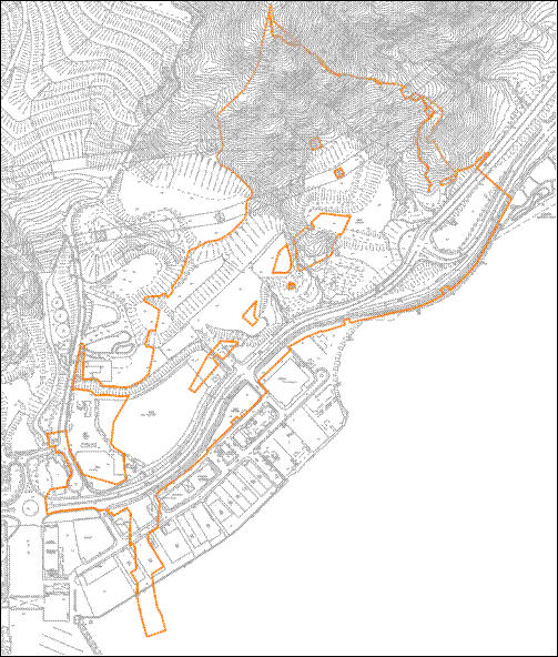
Figure 1.3 Site Boundary of HY/2013/12 - Northern
Connection Toll Plaza and Associated Works ��The Contract��
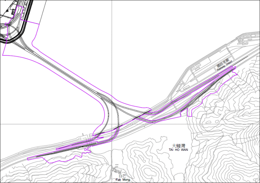
Figure 1.4 Site Boundary HY/2012/07, TMCLKL �V
Southern Connection Viaduct Section ��Contract 1��
Figure 1.5 Site Boundary HY/2012/08, TMCLKL �V
Northern Connection Sub-sea tunnel Section ��Contract 2��
Figure 2.1 Location
Map of Air Quality Monitoring Location
Figure
5.1 Location
of the Grave G1
Figure 5.2 General
View of the Grave G1
Figure 5.3 Existing
Cracks of the Grave G1
List of
TABLES
Table 2.1 Monitoring
Frequency and Parameter of Air Quality Monitoring Stations
Table 2.2 Air
Quality Monitoring Equipment
Table 2.3 TSP
Action and Limit Levels for Impact Air Quality Monitoring
Table 2.4 Event
/ Action Plan for Air Quality
Table 3 Pitcher
Plant Numbers and Health Condition Recorded in the Site in September 2013
Table 4.1 Baseline
Result for Landscape and Visual Impact
Table 4.2 Event
and Action Plan for Landscape and Visual Impact
Table 4.3 Proposed
Landscape and Visual Mitigation Measures
Table 4.4 Event
and Action Plan for Landscape and Visual Impact
Table 5.1 Crack
width and Photographic record of the Grave G1
Table 5.2 Event
/ Action Plan for Cultural Heritage
List of Appendices
Appendix A
Construction Programme
Appendix B
Habitat Map of Tuen Mun
Appendix C
Location of Pitcher Plant
Appendix D
Photographic Record of Baseline Condition for Landscape and Visual
Appendix E
Key Plan of Landscape and Visual Resource
1.1.1.1
According to the findings of the Northwest
New Territories (NWNT) Traffic and Infrastructure Review conducted by the
Transport Department, Tuen Mun Road, Ting Kau Bridge,
Lantau Link and North Lantau Highway (NLH) will be operating beyond capacity
after 2016 due to the increase in cross boundary traffic, developments in the
NWNT, and possible developments in North Lantau, including the Airport
developments, the Lantau Logistics Park (LLP) and the Hong Kong �V Zhuhai �V
Macao Bridge (HZMB). In order to cope with the anticipated traffic demand, two
new connections between NWNT and North Lantau �V Tuen Mun �V Chek
Lap Kok Link (TM-CLKL) and Tuen Mun Western Bypass (TMWB) are proposed.
1.1.1.2
The
construction of the Project to be undertaken comprises of several separate
contracts. The Contract number HY/2013/12
- Northern Connection Toll Plaza and Associated Works (hereinafter referred as
��the Contract��) is part of the Project, which is
located at Pillar Point in Tuen Mun Area 46.
1.1.1.3
Layout Plan of the Contract and various contracts of TM-CLKL were shows
in Figure
1.1 and 1.2 respectively.
Figure
1.3, 1.4 and 1.5 shows different site boundary of
each Contract of TM-CLKL:
Contract
1: HY/2012/07, TMCLKL �V Southern Connection Viaduct Section
Contract
2: HY/2012/08, TMCLKL �V Northern Connection Sub-sea tunnel Section
Contract
3: HY/2013/12 - Northern Connection Toll Plaza and Associated Works
1.1.1.4
CRBC-Kaden Joint Venture (hereafter ��CRBC-Kaden JV��) has been awarded by Highways
Department as the Main Contractor for the Contract in July 2014. The works of
the Contract mainly include:-
Ÿ
construction of an approximately 5.4 hectares
toll plaza and an associated footbridge;
Ÿ
construction of associated carriageways
including approximately 0.74 kilometre land viaducts,
and an approximately 230 metres vehicular underpass
to connect the toll plaza and the roundabout at Lung Mun Road/Lung Fu Road;
Ÿ
site formation for the construction of the
toll plaza, including associated slope works and natural terrain hazard
mitigation measures;
Ÿ
modification and realignment of the existing
Lung Mun Road and Lung Fu Road; and
Ÿ
associated
waterworks, drainage, sewerage and landscaping works, etc..
1.1.1.5
The
master construction programme is shown in Appendix A.
1.1.1.6
An Environmental Impact Assessment (EIA) was
prepared in accordance with the EIA Study Brief and the Technical Memorandum of
the Environmental Impact Assessment (EIAO-TM) which has been submitted under
the Environmental Impact Assessment Ordinance (EIAO Register Number
AEIAR-146/2009). An Environmental Permit (EP-354/2009) for TM-CLKL was granted
by the Director of Environmental Protection (DEP) on 4 November 2009, and EP
variations (EP-354/2009/A) issued on 8 December 2010 and (EP-354/2009/B) issued
on 28 January 2014 and (EP-354/2009/C) issued on 10 December 2014 and the
latest (EP-354/2009/D) issued on 13 March 2015.
1.1.1.7
Action-United Environmental Services &
Consulting (hereinafter referred as ��AUES��) has been commissioned as the
Contract Environmental Team (hereinafter referred as ��the ET��) to implement the
relevant EM&A program in accordance with the approved EM&A Manual and
the Contract requirements, as well as the associated duties.
1.2.1.1
In view of the major construction activities under
the Contract are land-based, the environmental aspects
such as water quality and marine ecological monitoring should not be related
the Contract works. Moreover, all
designated noise monitoring locations are located in Lantau and therefore noise
monitoring is not required under the Contract. In accordance with the Project EM&A
Manual requirements, air quality monitoring, ecological monitoring, cultural
heritage, landscape and visual monitoring and landfill gas
monitoring and site inspections should be covered in this Contract. Overall, the EM&A works follows the
demarcation of monitoring responsibilities set out in ENPO��s letter dated
16.10.2014.
1.2.1.2
The objective of this Baseline Monitoring
Report is to determine the baseline levels of the environmental aspect of air
quality, ecology, landscape and visual and cultural heritage around the Project
area prior to the commencement of any construction works of the Project.
1.3.1.1
The Baseline Monitoring Report is structured
into five sections as follow:
Section 1 Introduction
Section 2 Air
Quality Monitoring
Section 3 Ecology
Section 4 Landscape
and Visual
Section 5 Cultural
Heritage
Section 6 Conclusion
Figure
1.1 Layout Plan of the Contract
Figure
1.2 Various Contracts of TM-CLKL
Figure
1.3 Site Boundary of HY/2013/12
- Northern Connection Toll Plaza and Associated Works ��The Contract��
Figure
1.4 Site Boundary HY/2012/07,
TMCLKL �V Southern
Connection Viaduct Section ��Contract 1��
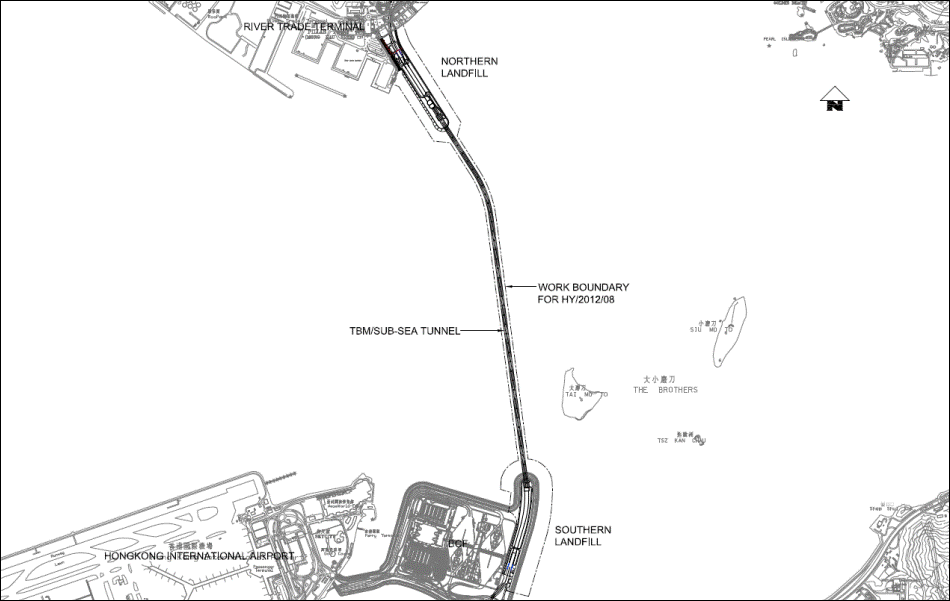
Figure
1.5 Site Boundary HY/2012/08,
TMCLKL �V Northern Connection Sub-sea tunnel Section ��Contract 2��
2.1.1.1
Baseline air
quality monitoring has been conducted by the ET of HyD
Contract HY/2012/08 between 17 and 31 October 2013 and the associated baseline
report has been submitted to the EPD for approval. It is agreed amongst by the Contractor,
RE, IEC that this Contract could make use of the baseline monitoring data
collected by the ET under HY/2012/08 and therefore no baseline monitoring is
required under this Contract.
2.2.1.1
The monitoring
stations for baseline air quality monitoring are shown Figure 2.1. Monitoring parameter, monitoring period
and frequency are summarized in Table
2.1.
Table 2.1 Monitoring Frequency and Parameter
of Air Quality Monitoring Stations
|
Air quality monitoring station
|
Location
|
Landuse
|
No. of Storey
|
Parameter
|
Period
|
Frequency
|
|
ASR1
|
Tuen Mun Fireboat Station
|
Office
|
1
|
1-hour TSP
24-hour TSP
|
07:00-19:00
for 1-hour TSP
24 hours for
24-hour TSP
|
3 times /
day for 1-hour TSP
Daily for
24-hour TSP
|
|
ASR5
|
Pillar Point Fire Station
|
Office
|
5
|
|
AQMS1
|
Previous River Trade Golf
|
Bare ground
|
0
|
|
ASR6
|
Butterfly Beach Laundry
|
Commercial
|
0
|
|
ASR10
|
Butterfly Beach Park
|
Recreational uses
|
0
|
2.3.1.1
High Volume Samplers
(HVS) were used to carry out 24-hour TSP monitoring. Direct reading dust meter
were also used to measure 1-hour average TSP levels. The 1-hour sampling was
determined periodically by HVS to check the validity and accuracy of the
results measured by direct reading method.
2.3.1.2
Wind data
monitoring equipment was set at rooftop of ASR5 (Pillar Point Fire Station) for
logging wind speed and wind direction such that the wind sensors are clear of
obstructions or turbulence caused by building. The wind data monitoring
equipment is recalibrated at least once every six months and the wind
directions are divided into 16 sectors of 22.5 degrees each.
2.3.1.3
Table 2.2 summarizes the equipment used in the baseline air quality monitoring
programme.
Table 2.2 Air
Quality Monitoring Equipment
|
Equipment
|
Model and Make
|
|
HVS Sampler
|
GMWS-2310 ACCU-VOL
|
|
Calibrator
|
CM-AIR-43 (S/N 9833620)
|
|
1-hour TSP Dust Meter
|
Sibata LD-3B
|
|
Wind Anemometer
|
MetPak, WindSonic
|
24-hour TSP
Instrumentation
2.4.1.1
High volume Samplers
(HVS) completed with appropriate sampling inlets were
employed for air quality monitoring. Each sampler was composed of a motor, a
filter holder, a flow controller and a sampling inlet and its performance
specification complies with that required by USEPA Standard Title 40, Code of
Federation Regulations Chapter 1 (Part 50).
HVS
Installation
2.4.1.2
The
following guidelines were adopted during the installation of HVS:
Ÿ
Sufficient support was provided to secure the
samplers against gusty wind.
Ÿ
No two samplers were placed less than 2
meters apart.
Ÿ
The distance between the sampler and an
obstacle, such as buildings, was at least twice the height that the obstacle
protrudes above the sampler.
Ÿ
A minimum of 2 meters of separation from
walls, parapets and penthouses was required for rooftop samples.
Ÿ
A minimum of 2 meters separation from any
supporting structure, measured horizontally was required.
Ÿ
No furnaces or incineration flues were
nearby.
Ÿ
Airflow around the sampler was unrestricted.
The samplers were more than 20 meters from
the drip line.
Ÿ
Any wire fence and gate, to protect the
sampler, should not cause any obstruction during monitoring.
Filter
Preparation
2.4.1.3
Fiberglass filters
were used [Note: these filters have a collection efficiency of larger than 99%
for particles of 0.3�gm diameter]. A HOKLAS accredited laboratory was
responsible for the preparation of 24-hr conditioned and preweighed
filter papers for monitoring team.
2.4.1.4
All prepared
filters were equilibrated in the conditioning environment for 24 hours before
weighing. The conditioning environment temperature was around 25 �XC and not
variable by more than ��3 �XC; the relative humidity (RH) was <50% and not
variable by more than ��5%. A convenient working RH was 40%.
Operating/
Analytical Procedures
2.4.1.5
Operating/analytical
procedures for the air quality monitoring were highlighted as follows:
Ÿ
Prior to the commencement of the dust
sampling, the flow rate of the HVS was properly set (between 1.1 m3/min. and
1.4 m3/min.) in accordance with the manufacturer's instruction to within the
range recommended in USEPA Standard Title 40, CFR Part 50.
Ÿ
The power supply was checked to ensure the
sampler worked properly.
Ÿ
On sampling, the sampler was operated for 5
minutes to establish thermal equilibrium before placing any filter media at the
designated air quality monitoring station.
Ÿ
The filter holding frame was then removed by
loosening the four nuts and carefully a weighted and conditioned filter was
centered with the stamped number upwards, on a supporting screen.
Ÿ
The filter was aligned on the screen so that
the gasket formed an airtight seal on the outer edges of the filter. Then the
filter holding frame was tightened to the filter holder with swing bolts. The
applied pressure should be sufficient to avoid air leakage at the edges.
Ÿ
The shelter lid was closed and secured with
the aluminum strip.
Ÿ
The timer was then programmed. Information
was recorded on the record sheet, which included the starting time, the weather
condition and the filter number (the initial weight of the filter paper can be
found out by using the filter number).
Ÿ
After sampling, the filter was removed and
sent to the laboratory for weighing. The elapsed time was also recorded.
Ÿ
Before weighing, all filters were
equilibrated in a conditioning environment for 24 hours. The conditioning
environment temperature should be between 25�XC and 30�XC and not vary by more
than ��3�XC; the relative humidity (RH) should be < 50% and not vary by more
than ��5%. A convenient working RH is 40%. Weighing results were used for
further analysis of TSP concentrations collected by each filter.
Maintenance
and Calibration
2.4.1.6
The following
maintenance/calibration was required for the HVS:
Ÿ
The high volume motors and their accessories
were properly maintained. Appropriate maintenance such as routine motor brushes
replacement and electrical wiring checking were made to ensure that the
equipment and necessary power supply are in good working condition.
Ÿ
All HVS were calibrated (five point
calibration) using Calibration Kit prior to the commencement of the baseline
monitoring and thereafter at bi-monthly intervals.
1-hour TSP
Measuring
Procedures
2.4.1.7
The
measuring procedures of the 1-hour dust meter are in accordance with the
Manufacturer��s Instruction Manual as follows:
Ÿ
The 1-hour dust meter is placed at least 1.3
meters above ground.
Ÿ
Set POWER to ��ON�� and make sure that the
battery level was not flash or in low level.
Ÿ
Allow the instrument to stand for about 3
minutes and then the cap of the air sampling inlet has been released.
Ÿ
Push the knob at MEASURE position.
Ÿ
Set time/mode setting to [BG] by pushing the
time setting switch. Then, start the background measurement by pushing the
start/stop switch once. It will take 6 sec. to complete the background
measurement.
Ÿ
Push the time setting switch to change the
time setting display to [MANUAL] at the bottom left of the liquid crystal
display. Finally, push the start/stop switch to stop the measuring after 1 hour
sampling.
Ÿ
Information such as sampling date, time, count value and site condition were recorded during the monitoring
period.
Maintenance
and Calibration
2.4.1.8
The following
maintenance/calibration is required for the 1-hour dust meter;
Ÿ
Check and calibrate the meter by HVS to check
the validity and accuracy of the results measured by direct reading method at
2-month intervals throughout all stages of the air quality monitoring.
2.5.1.1
The monitoring
results, name of laboratory and calibration details, and QA/QC results and
detection limits to be referred to the Baseline Monitoring Report under the
Contract HY/2012/08.
2.6.1.1
The baseline monitoring results formed the
basis for determining the air quality criteria for the impact monitoring. The
ET shall compare the impact monitoring results with air quality criteria set up
for 24-hour TSP and 1-hour TSP. Based
on results of the approved Baseline Monitoring Report of HyD
Contract HY/2012/08, the proposed Action and Limit Levels are shown in Tables
2.3.
Table 2.3 TSP
Action and Limit Levels for Impact Air Quality Monitoring
|
Parameters
|
Air
Quality Monitoring Stations
|
Action Level
(�gg/m3)
|
Limit Level
(�gg/m3)
|
|
24 hour TSP (�gg/m3)
|
ASR1
|
213
|
260
|
|
ASR5
|
238
|
260
|
|
AQMS1
|
213
|
260
|
|
ASR6
|
238
|
260
|
|
ASR10
|
214
|
260
|
|
1 hour TSP (�gg/m3)
|
ASR1
|
331
|
500
|
|
ASR5
|
340
|
500
|
|
AQMS1
|
335
|
500
|
|
ASR6
|
338
|
500
|
|
ASR10
|
337
|
500
|
2.7.1.1
In case of non-compliance with the air
quality criteria, more frequent monitoring exercise shall be conducted within
24 hours after the result is obtained. This additional monitoring shall be
continued until the excessive dust emission or the deterioration in air quality
is rectified. The Event/Action Plan
for air quality is given in the attached Table
2.4.
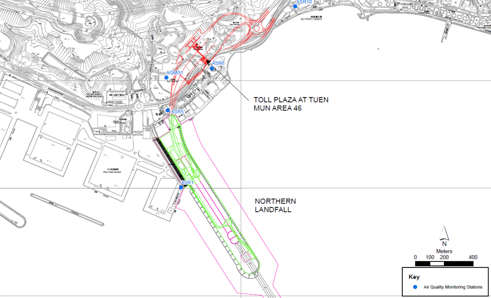
Figure 2.1 Location Map of Air
Quality Monitoring Location
Table 2.4 Event /
Action Plan for Air Quality
|
EVENT
|
ACTION
|
|
ET(1)
|
IEC(1)
|
SOR(1)
|
Contractor(s)
|
|
Action Level
|
|
Exceedance recorded
|
1
Identify the
source.
2
Repeat
measurements to confirm findings. If two consecutive measurements exceed
Action Level, the exceedance is then confirmed.
3
Inform the IEC,
SOR and the Contractor.
4
Investigate
the cause of exceedance and check Contractor��s working procedures to determine possible mitigation to be implemented.
5
If the exceedance is confirmed to be
Project related after investigation, increase monitoring frequency to daily.
6
Discuss with the IEC and the Contractor on
remedial actions required.
7
If exceedance continues, arrange meeting
with the IEC and the SOR.
8
If exceedance stops, cease additional
monitoring.
|
1
Check
monitoring data submitted by the ET.
2
Check the Contractor��s
working method.
3
If the
exceedance is confirmed to be Project related after investigation, discuss
with the ET and the Contractor on possible remedial measures.
4
Advise the
SOR on the effectiveness of the proposed remedial measures.
5
Supervise implementation
of remedial measures.
|
1
Confirm
receipt of notification of failure in writing.
2
Notify the
Contractor.
3
Ensure
remedial measures properly implemented.
|
1
Rectify any
unacceptable practice.
2
Amend
working methods if appropriate
3
If the
exceedance is confirmed to be Project related, submit proposals for remedial
actions to IEC within 3 working days of notification
4
Implement
the agreed proposals
5
Amend
proposal if appropriate.
|
|
Limit Level
|
|
Exceedance recorded
|
1.
Identify the
source.
2.
Repeat measurement to confirm finding. If
two consecutive
measurements exceed Limit Level, the exceedance
is then confirmed.
3.
Inform the IEC, the SOR, the DEP and the
Contractor.
4.
Investigate the cause of exceedance and
check Contractor��s working procedures to determine possible mitigation to be
implemented.
5.
If the exceedance is confirmed to be
Project related after investigation, increase monitoring frequency to daily.
6.
Carry out analysis of the Contractor��s
working procedures to determine possible mitigation to be implemented.
7.
Arrange meeting with the IEC and the SOR to
discuss the remedial actions to be taken.
8.
Assess effectiveness of the Contractor��s
remedial actions and keep the IEC, the DEP and the SOR informed of the
results.
9.
If exceedance stops, cease additional
monitoring.
|
1
Check
monitoring data submitted by
the ET.
2
Check
Contractor��s working method.
3
If the
exceedance is confirmed to be Project related after investigation, discuss
with the ET and the Contractor on possible remedial measures.
4
Advise the SOR
on the effectiveness of the proposed remedial measures.
5
Supervise implementation
of remedial measures.
|
1.
Confirm receipt of notification of failure
in writing.
2.
Notify the Contractor.
3.
If the exceedance is confirmed to be
Project related after
investigation, in consultation with
the IEC, agree with the
Contractor on the remedial
measures to be implemented.
4.
Ensure remedial measures are properly
implemented.
5.
If exceedance continues, consider what activity of the work is responsible and instruct the Contractor to stop that activity of work until the exceedance is abated.
|
1
Take
immediate action to avoid further exceedance.
2
If the
exceedance is confirmed to be Project related after investigation, submit
proposals for remedial actions to IEC within 3 working days of notification.
3
Implement the
agreed proposals.
4
Amend
proposal if appropriate.
5
Stop the
relevant activity of works as determined by the SOR until the exceedance is
abated.
|
Note: ET �V Environmental Team, IEC �V
Independent Environmental Checker, SOR �V Supervising Office��s Representative
3.1.1.1
Ecological
baseline EM&A will consist of undertaking the following:
Ÿ
a walk-over survey, prior to
construction works, of the land and streams where works will be undertaken. It
may be necessary to rope off and protect specific habitats or species of
special interest identified during the ecological surveys
3.2.1.1
The
purpose of the walk over survey will be to confirm the existing ecological conditions,
with reference to the habitat maps included in the EIA Report and the established
baseline conditions, in relation to the extent and condition of the habitats
and species noted during the walkover survey. No detailed ecological surveys of flora
and fauna will be required at this stage.
3.2.1.2
Baseline
ecological walkover was conducted on 22 September 2014 and the results are
presented in below.
Observations
3.2.1.3
Two
major landscapes within the study area were tall shrubland
and plantation according to the habitat map in the approved EIA Report. To better record specific species of
native trees and shrubland, a general record about
their habit of growth was made.
Tall Shrubland
3.2.1.4
Shrubland habitat is densely populated with a mix native tree shrubby plant species
within study area. Native tree like Acacia confuse as well as other shrubby plant species are
planted broadly in this area. Shrublands are widely distributed.
The most common one are the Acacia confusa, Leucaena leucocephala, Macaranga tanarius and Clausena lansium. They have mixed with each other and get better greening benefit. No significant change to habitat maps in
the EIA Report was observed.
Plantation
3.2.1.5
Plantation
at the study area contain mainly roadside plantation for landscape use within
the study area. The plantation part, trees, for instance, Ficus microcarpa and Ficus elastica are most widely used as
roadside (riverside) plant and landscape greening. They are common evergreen
trees in Hong Kong and can grow as tall as fifteen meters which are considered
to be very aggressive. No significant change to habitat maps in the EIA Report
was observed.
Stream
3.2.1.6
The
outlet of the stream opposite to the
River Trade Terminal is now modified to an artificial culvert. Other than that,
the habitat types within the Study area are similar to the habitat maps in the EIA report.
3.2.1.7
The
developed area such as warehouses and River Trade Terminal was observed. No significant change to habitat maps in
the EIA Report was observed.
3.2.1.8
Part
of the Butterfly Beach as designated in EIA, is located at the eastern side of
the pillar point. No significant change
to habitat maps in the EIA Report was observed.
3.2.1.9
The
habitat map of Tuen Mun is shown in Appendix B.
3.3.1.1
During the Environmental Impact Assessment
(EIA) Stage of the TM-CLKL (which was approved on 23 October 2009), no Pitcher
Plant (Nepenthes mirabilis) was identified within the proposed works
area of the toll plaza. It was believed that the Pitcher Plant area identified
would not be directly impacted by the toll plaza works and the only mitigation measures
required were to install hoarding at the perimeter of the proposed works area
to avoid encroachment into the Pitcher Plant area. However, during an ecology
survey for the TMWB EIA in late 2011, Pitcher Plant was identified within the
proposed works area for the TM-CLKL toll plaza. Pitcher Plant is protected under the
Forestry Regulations (subsidiary legislation of the Forests and Countryside
Ordinance, Cap. 96) and the Protection of Endangered Species of Animals and
Plants Ordinance (Cap. 586). Discussion with Agriculture, Fisheries and
Conservation Department (AFCD) (27 October 2012) has confirmed that if the
TM-CLKL project was to impact the Pitcher Plant area that further mitigation
measures for the Pitcher Plant would be required under the TM-CLKL project. As
such, the project proponent Highways Department (HyD)
has appointed AECOM to undertake baseline survey and propose a transplantation strategy
for Pitcher Plant to be affected by the proposed TM-CLKL project.
3.3.1.2
A baseline Pitcher Plant survey was conducted
in September 2013 by a suitably qualified ecologist. The aim of the survey was to update,
identify and record the location, number, health condition (i.e. good, fair, or
poor), and suitability for transplantation of the affected individuals in order
to provide details for the transplantation exercise. Each identified individual
was tagged. The habitats present and representative plant species were
recorded.
3.3.1.3
The assessment area included the slope above
the toll plaza on which the Pitcher Plant populations have been previously
identified. The slope was surveyed
to identify the extent of the Pitcher Plant populations particularly those that
occur within and adjacent to the proposed works site.
Baseline Results on September 2013
3.3.1.4
The south-facing slope above the proposed
toll plaza supports a mosaic of shrubland, rocky
slope, plantation and watercourse habitats. Pitcher
Plant was recorded in the rocky slope, shrubland and
watercourse habitats. The rocky slope habitat comprised some exposed boulders
and bare ground; however, much of it has been naturally regenerated by shrubland species such as Dichotomy Forked Fern (Dicranopteris pedata), with
some encroachment by scattered Brisbane Box (Lophostemon confertus) saplings from the adjacent
plantation habitat. This habitat supported a Pitcher Plant population (see Zones 1-7 in Appendix C)
of
approximately 0.5 ha in size and 259 Pitcher Plants (see Appendix C,
Plates 1-3)).
3.3.1.5
In addition, three small areas (see Zones 8 �V 10 in Appendix C) of Pitcher Plant were recorded along
the watercourse in the shrubland habitat (see Appendix C,
Plate 4).
The watercourse comprised a narrow, shallow flow over bedrock with occasional
small, very shallow pooled areas. There is evidence that part of the flow is
being diverted for human use. Riparian vegetation comprised the shrubland habitat in which the watercourse flowed. Abundant
tree/shrub species found in the shrubland habitat
included Dwarf Mountain Pine (Baeckea frutescens), Pop-gun
Seed (Bridelia tomentosa), Eurya spp., Hong Kong Gordonia (Gordonia axillaris),
Pond Spice (Litsea glutinosa),
Pines (Pinus spp.), Wild Coffee (Psychotria asiatica), Rose Myrtle (Rhodomyrtus tomentosa),
Hedge Sageretia (Sageretia thea), and Brisbane Box (Lophostemon confertus).
While the understorey was dominated by Dichotomy
Forked Fern (Dicranopteris pedata), with
frequent Greenbrier (Smilax china),
and occasional Hainan Galangal (Alpinia hainanensis), Oriental Blechnum
(Blechnum orientale),
Bentham��s Rosewood (Dalbergia benthami), Dianella (Dianella ensifolia), and Chinese Silvergrass
(Miscanthus sinensis).
3.3.1.6
The health and condition of the Pitcher Plant
individuals was assessed and each plant was assessed, tagged and photographed
by Pegasus Greenland Ltd.. All plants were assessed as
being in ��fair�� health condition as summarized in Table 3. As the plants mostly grew on rock faces
with thin soils, the successful removal and transport of the existing
individuals is likely to be challenging given the weak nature of the plant��s
roots.
Table 3 Pitcher
Plant Numbers and Health Condition Recorded in the Site in September 2013
|
Zone
|
No. of Plants Found
|
Health
Condition
|
|
1
|
3
|
Fair
|
|
2
|
1
|
Fair
|
|
3
|
15
|
Fair
|
|
4
|
6
|
Fair
|
|
5
|
33
|
Fair
|
|
6
|
185
|
Fair
|
|
7
|
16
|
Fair
|
|
8
|
3
|
Fair
|
|
9
|
8
|
Fair
|
|
10
|
10
|
Fair
|
|
TOTAL
|
280
|
|
Baseline Results on September 2014
3.3.1.7
Before commencement of the construction of
the Contract, the initial survey was conducted by Hong Kong Landscape in
September 2014 to confirm the location and number of the affected Pitcher Plants
by the proposed TM-CLKL project. During
the initial survey in September 2014, a total of 280 nos. of individual Pitcher
Plant located at Zone 1 to 7 was identified. They are occurring on the rocky slope
habitat which will be impacted by the proposed slope works (Zone 1 to 7). Each identified individual were tagged
and photographed. The location map
of the pitcher plants is shown in Appendix C.
3.3.1.8
280 nos. of Pitcher Plants identified in the
initial survey will require transplantation to minimize impacts to the
population. For those unaffected
Pitcher Plant in Zone 8 to 10, fencing or other physical barriers will be
erected for protection.
3.3.1.9
A transplantation proposal for Pitcher Plant in Zone 1 to 7 was submitted
to EPD and AFCD for agreement separately.
4.1.1.1
A
one off survey shall be conducted prior to commencement of any construction works.
A photographic record of the site
at the time of the contractor��s possession of the site shall be prepared by the
Contractor and approved by the ER.
4.2.1.1
Baseline
walkover for the exiting landscape condition was conducted on 22 September 2014.
During the baseline monitoring,
apart from the temporary river trade golf at LR03 was demolished and abandoned,
LR01 to LR07 were identified as same as the EIA study.
4.2.1.2
The
photographic record and monitoring results are shown in Table
4.1 and 4.2. The
proposed landscape and visual mitigation measures for
construction and operation phase are
listed in Table 4.3. Key plan showing the location and extent of existing landscape and visual
resource is shown in Appendix E.
4.2.1.3
Moreover,
a photographic record of baseline condition prepared by the RE was submitted to
EPD on 29 September 2014 and the record is presented in Appendix D as
supplementary information.
Observations
Table 4.1 Baseline
Result for Landscape and Visual Impact
|
Existing
Landscape Resources
|
Photographic record
|
|
Seawater body and shoreline near Pillar Point (LR01)
|
This
landscape resources only covered in HY/2012/08, TMCLKL �V Northern Connection Sub-sea
tunnel Section Contract.
|
|
Plantation within the industrial
area and sewage treatment plant at Pillar Point (LR02)
|
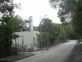
|
|
Temporary
River Trade Golf (LR03)
|
|
|
Tall Shrubland (LR04)
|
|
|
Stream (LR05)
|
|
|
Plantation (LR06)
|
|
|
Sandy Beach (LR07)
|
|
|
Seawater body and shoreline north of Tai Ho Wan (LR08)
|
This
landscape resources only covered in HY/2012/07, TMCLKL �V Southern Connection
Viaduct Section contract.
|
|
Tai Ho Wan
(LR09)
|
This
landscape resources only covered in HY/2012/07, TMCLKL �V Southern Connection
Viaduct Section contract.
|
|
Roadside planting along North Lantau Highway and within MTR Siu Ho Wan
Depot (LR10)
|
This
landscape resources only covered in HY/2012/07, TMCLKL �V Southern Connection
Viaduct Section contract.
|
|
Vegetation at Tai Ho and Pak Mong (LR11)
|
This
landscape resources only covered in HY/2012/07, TMCLKL �V Southern Connection
Viaduct Section contract.
|
|
Stream course at Pak Mong (LR12)
|
This
landscape resources only covered in HY/2012/07, TMCLKL �V Southern Connection
Viaduct Section contract.
|
|
Pitcher
Plant at future Toll Plaza area (Additional LR)
|
|
|
Siu Lang Shui Upland and
Hillside Landscape (LCA01)
|
|
|
Pillar Point Miscellaneous Urban
Fringe Landscape
(LCA02)
|
|
|
Pillar Point Industrial Urban Landscape (LCA03)
|
This
landscape resources only covered in HY/2012/08, TMCLKL �V Northern Connection
Sub-sea tunnel Section Contract.
|
|
Inshore Water Landscape near Pillar
Point (LCA04)
|
This
landscape resources only covered in HY/2012/08, TMCLKL �V Northern Connection
Sub-sea tunnel Section Contract.
|
|
North Lantau Transportation Corridor
Landscape
(LCA05)
|
This
landscape resources only covered in HY/2012/07, TMCLKL �V Southern Connection
Viaduct Section contract.
|
|
Tai Ho Upland and Hillside Landscape (LCA06)
|
This landscape
resources only covered in HY/2012/07, TMCLKL �V Southern Connection Viaduct
Section contract.
|
|
Tai Ho Settled Valley Landscape (LCA07)
|
This
landscape resources only covered in HY/2012/07, TMCLKL �V Southern Connection
Viaduct Section contract.
|
|
Pak Mong
Upland and Hillside Landscape
(LCA08)
|
This
landscape resources only covered in HY/2012/07, TMCLKL �V Southern Connection
Viaduct Section contract.
|
|
Inshore Water Landscape near Tai Ho (LCA09)
|
This
landscape resources only covered in HY/2012/07, TMCLKL �V Southern Connection
Viaduct Section contract.
|
Table
4.2 Baseline Result for Landscape Resources and Landscape Character Areas
|
Existing
Landscape Resources
|
Baseline
Condition
|
Description
of Impacts
|
Remedial
Works
|
|
Seawater body and shoreline near Pillar Point (LR01)
|
This landscape resources only covered in HY/2012/08, TMCLKL
�V Northern Connection Sub-sea tunnel Section Contract.
|
|
Plantation within the industrial area and sewage
treatment plant at Pillar Point (LR02)
|
Plantation within the industrial
area and sewage treatment plant at Pillar Point
There are approximately 240 trees at this developed industrial
site. The trees are of small to medium size (height: 3-12m, spread: 2-6m,
trunk diameter: 95-400mm) and of low to medium amenity value.
|
�P
approximately 140 no. of trees
will be affected, of which approximately 2 no. of trees are proposed to be
transplanted, approximately 10 no. of trees are proposed to be felled,
approximately 130 no. of weed trees (Leucaena
leucocephala) are proposed to be removed.
�P
felled trees are mainly Acacia confusa
of low amenity value.
|
CM1,
CM2, CM9, CM10 and OM4
|
|
Temporary River Trade Golf (LR03)
|
Abandon River Trade Golf
The Abandon River
Trade Golf is classified as developed area. There are 50 Acacia
confusa, Caryota ochlandra of medium size and of low to medium
amenity value. Due to the artificial and temporary nature, the sensitivity of
this landscape resource is considered as medium.
|
�P Abandoned
River Trade Golf and will be
permanently lost
|
CM1,
CM2, CM9, CM10 and OM4
|
|
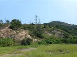
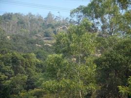
Tall Shrubland (LR04)
|
Tall
shrubland and disturbed hillside plantation area at
Pillar Point
The area consists of tall
shrubland and disturbed hillside plantation. There
are more than 3000 trees and tall shrubs on the slope and plantation. The
trees are mostly of low to medium size together with approximately 20 mature
trees (height: 2-16m, spread: 0.5-10m, trunk diameter: 95-820mm) and of small
to medium amenity value.
|
�P
approximately 2600 no. of trees will be affected, of which
approximately 2300 no. of trees are proposed to be felled, approximately 300
no. of weed trees (Leucaena leucocephala) are proposed to be removed.
�P
felled trees are mainly Acacia confusa,
Casuarina equisetifolia, Clausena
lansium, Dimocarpus
longan, Eucalyptus torelliana,
Litchi chinensis, Lophostemon
confertus, Macaranga
tanarius. The trees are of low to medium
amenity value
�P
approximately 4.2ha tall shrubland will be lost permanently
|
CM1,
CM2, CM9, CM10 and OM1
|
|
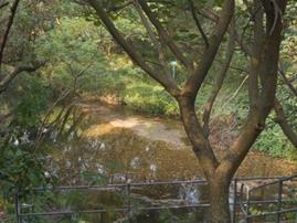
Stream (LR05)
|
Stream course at Pillar Point
The
small stream is partly artificial and partly natural. There are several
patches of Rhododendron simsii near the stream.
|
�P
N.A.
|
CM7
|
|
Plantation (LR06)
|
Roadside
planting along Lung Mun Road
There are approximately
600 trees along the roadside. The trees are of medium size (height: 1.5-13m,
spread: 0.5-8m, trunk diameter: 95-760mm) and of low to medium amenity value.
|
�P
approximately 260 no. of trees
will be affected, of which approximately 20 no. of trees are proposed to be
transplanted, approximately 200 no. of trees are proposed to be felled,
approximately 40 no. of weed trees (Leucaena
leucocephala) are proposed to be removed.
�P
felled trees are mainly Acacia confusa
of low amenity value.
|
CM1,
CM2, CM9, CM10 and OM4
|
|
Sandy Beach (LR07)
|
None
|
�P
N.A.
|
Nil
|
|
Seawater body and shoreline north of Tai Ho Wan (LR08)
|
This landscape resources only covered in HY/2010/02, HKBCF �V
Reclamation Works contract.
|
|
Tai Ho Wan (LR09)
|
This landscape resources only covered in HY/2010/02, HKBCF �V
Reclamation Works contract.
|
|
Roadside planting along North Lantau Highway and within
MTR Siu Ho Wan Depot (LR10)
|
This landscape resources only covered in HY/2010/02, HKBCF �V
Reclamation Works contract.
|
|
Vegetation at Tai Ho and Pak Mong (LR11)
|
This landscape resources only covered in HY/2012/07, TMCLKL
�V Southern Connection Viaduct Section contract.
|
|
Stream course at Pak Mong (LR12)
|
This landscape resources only covered in HY/2012/07, TMCLKL
�V Southern Connection Viaduct Section contract.
|
|
Pitcher Plant (Additional LR)
|
Existing Pitcher Plant
There are 280 pitcher plant within the construction area of the future toll
plaza.
|
�P
The Construction of the future
Toll Plaza underpass at Tuen Mun will affect the protected Pitcher Plant at
that location. Therefore, it was proposed to transplant the affected Pitcher
Plant.
|
Pitcher
Plant unavoidably affected by the works shall be transplanted subject to the
approval of AFCD and EPD. The transplantation works should strictly comply
with the condition as stipulated in the license issued by AFCD and the VEP
issued by EPD.
|
|
Siu Lang Shui Upland and Hillside Landscape
(LCA01)
|
Siu Lang
Shui Upland and Hillside Landscape
This is upland and hillside lie above 40mPD and below 300mPD in
which part of the area is former landfill site. The area is dominated with
tall shrubland and plantation of medium amenity
value. The area is predominantly undeveloped with occasional small buildings.
|
�P
Toll plaza, slope works and retaining walls are incompatible to undisturbed
hillside landscape. More than 1000 trees and approximately 4.2ha
tall shrubland will be lost permanently, leading to
change in landscape quality
|
CM1,
CM2, CM9, CM10, OM1
|
|
Pillar Point Miscellaneous Urban Fringe Landscape (LCA02)
|
Pillar Point Miscellaneous Urban Fringe Landscape
The generally low rise developments within the area are of mixed
land uses, including typically highways, transportation, storage, parks,
residential sites and undeveloped land (hillside). The area is located at the
edge of urbanized area.
|
�P
Toll plaza, slope works and retaining walls are not incompatible to
miscellaneous urban fringe landscape which consisted of mixed land uses such
as highways, transportation. More than 1000 will be lost permanently,
leading to change in landscape quality
|
CM1,
CM2, CM9, CM10 and OM1
|
|
Pillar Point Industrial Urban Landscape (LCA03)
|
This landscape resources only covered in HY/2012/08, TMCLKL
�V Northern Connection Sub-sea tunnel Section Contract.
|
|
Inshore Water Landscape near Pillar Point (LCA04)
|
This landscape resources only covered in HY/2012/08, TMCLKL
�V Northern Connection Sub-sea tunnel Section Contract.
|
|
North Lantau Transportation Corridor Landscape (LCA05)
|
This landscape resources only covered in HY/2012/07, TMCLKL
�V Southern Connection Viaduct Section contract.
|
|
Tai Ho Upland and Hillside Landscape (LCA06)
|
This landscape resources only covered in HY/2012/07, TMCLKL
�V Southern Connection Viaduct Section contract.
|
|
Tai Ho Settled Valley Landscape (LCA07)
|
This landscape resources only covered in HY/2012/07, TMCLKL
�V Southern Connection Viaduct Section contract.
|
|
Pak Mong Upland and Hillside
Landscape (LCA08)
|
This landscape resources only covered in HY/2012/07, TMCLKL
�V Southern Connection Viaduct Section contract.
|
|
Inshore Water Landscape near Tai Ho (LCA09)
|
This landscape resources only covered in HY/2012/07, TMCLKL
�V Southern Connection Viaduct Section contract.
|
Table
4.3 Proposed
Landscape and Visual Mitigation Measures
|
ID No.
|
Construction Phase Mitigation Measures
|
|
CM1
|
Existing trees on boundary of the Project
Area shall be carefully protected during construction. Detailed Tree
Protection Specification shall be provided in the Contract Specification.
Under this specification, the Contractor shall be required to submit, for
approval, a detailed working method statement for the protection of trees
prior to undertaking any works adjacent to all retained trees, including
trees in contractor��s works areas. (Tree protection measures will be detailed
at Tree Removal Application stage).
|
|
CM2
|
Trees unavoidably affected by the works
shall be transplanted where practical. Trees will be transplanted straight to
their final receptor site and not held in a temporary nursery. A detailed
Tree Transplanting Specification shall be provided in the Contract
Specification. Sufficient time for necessary tree root and crown preparation
periods shall be allowed in the project programme.
|
|
CM3
|
Hillside and roadside screen planting to
proposed roads, associated structures and slope works.
|
|
CM4
|
Hydroseeding
or sheeting of soil stockpiles with visually unobtrusive material (in earth
tone).
|
|
CM5
|
Screening of construction works by hoardings around
works area in visually unobtrusive colours, to
screen works.
|
|
CM6
|
Control night-time lighting and glare by hooding all
lights.
|
|
CM7
|
Ensure no run-off into water body adjacent
to the Project Area.
|
|
CM8
|
Avoidance of excessive height and bulk of
buildings and structures.
|
|
CM9
|
Recycle/Reuse all felled trees and
vegetation practicable, e.g. mulching
|
|
CM10
|
Compensatory tree planting shall be
provided to the satisfaction of relevant Government departments. Required
numbers and locations of compensatory trees shall be determined and agreed
separately with Government during the Tree Felling Application process under
ETWBTC 3/2006
|
|
ID No.
|
Operation Phase Mitigation Measures
|
|
OM1
|
Re-vegetation of affected woodland/shrubland with native species.
|
|
OM2
|
Tall buffer screen tree / shrub / climber planting
should be incorporated to soften hard engineering structures and facilities.
|
|
OM3
|
Streetscape elements (e.g. paving, signage, street
furniture, lighting etc.) shall be sensitively designed in a manner that
responds to the local context, and minimises
potential negative landscape and visual impacts. Lighting units should be
directional and minimise unnecessary light spill.
|
|
OM4
|
Structure, ornamental tree / shrub /
climber planting should be provided along roadside amenity strips, central
dividers and newly formed slopes to enhance the townscape quality and further
greenery enhancement.
|
|
OM5
|
Aesthetically pleasing design (visually unobtrusive and
non-reflective) as regard to the form, material and finishes shall be
incorporated to all buildings, engineering structures and associated
infrastructure facilities.
|
|
OM6
|
Avoidance of excessive height and bulk of buildings and
structures
|
4.3.1.1
Should
non-compliance of the landscape and visual impacts occur, actions in accordance
with the action plan stated in Table 4.2 should be carried out.
Table 4.4 Event
and Action Plan for Landscape and Visual Impact
|
Event ACTION LEVEL
|
ACTION
|
|
ET
|
IEC
|
Permit
Holder
|
Contractor
|
|
Design
Check
|
Ÿ
Check
final design conforms to the requirements of EP and prepare report.
|
Ÿ Check report.
Ÿ Recommend remedial design if necessary
|
Ÿ
Undertake
remedial design if necessary
|
|
|
Non-
conformity on one occasion
|
Ÿ
Identify
Source
Ÿ
Inform
IEC and Permit Holder
Ÿ
Discuss
remedial actions with IEC, Permit Holder and
Contractor
Ÿ
Monitor
remedial actions until rectification has been completed
|
Ÿ Check report
Ÿ Check Contractor's working method
Ÿ Discuss with ET and Contractor on possible remedial
measures
Ÿ Advise Permit Holder on
effectiveness of proposed remedial measures.
Ÿ Check implementation of remedial measures
|
Ÿ
Notify
Contractor
Ÿ
Ensure
remedial measures are properly implemented
|
Ÿ
Amend
working methods
Ÿ
Rectify
damage and undertake any necessary replacement
|
|
Repeated
Non- conformity
|
Ÿ
Identify
Source
Ÿ
Inform
IEC and Permit Holder
Ÿ
Increase
monitoring frequency
Ÿ
Discuss
remedial actions with IEC, Permit Holder
and Contractor
Ÿ
Monitor
remedial actions until rectification has been completed
Ÿ
If
nonconformity stops, cease additional monitoring
|
Ÿ Check monitoring report
Ÿ Check Contractor's working method
Ÿ Discuss with ET and Contractor on possible remedial
measures
Ÿ Advise Permit Holder on
effectiveness of proposed remedial measures
Ÿ Supervise implementation of remedial measures
|
Ÿ
Notify
Contractor
Ÿ
Ensure
remedial measures are properly implemented
|
Ÿ
Amend
working methods
Ÿ
Rectify
damage and undertake any necessary replacement
|
5.1.1.1
The
EIA has recommended that EM&A for cultural heritage resources is undertaken
during construction phase of the project. Implementation of the mitigation
measures recommended by the EIA will be monitored through the site audit
programme.
5.2.1.1
Prior
to construction, a baseline survey of the grave G1 should be undertaken to
establish the existing condition.
5.2.1.2
The
purpose of the baseline condition survey was to record the existing condition
of the grave and comprised the following task.
1.
Identification of grave near the Project Site;
2.
Carry out visual inspection for the condition
survey;
3.
Record the existing condition and evaluation
of structural integrity of the grave;
4.
Record the exact location of the grave prior
to construction commencement. This information formed the baseline information
for reference during construction phase;
5.
Submission of all records such as
photographs, grave locations, all detected cracks, defects and damage, if any.
5.3.1.1
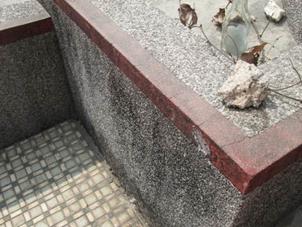
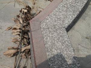
The condition survey was conducted on 23
September 2014 and the finding area presented below.
5.3.1.2
The historical grave was identified during
the EIA stage of the project and the location of the grave (G1) was shown in Figure
5.1. It was observed that
plenty of bushes was grown around the grave. The general view of the grave was shown
in Figure
5.2.
5.4.1.1
The Grave G1 is generally in good
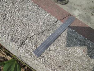
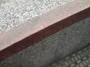
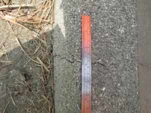
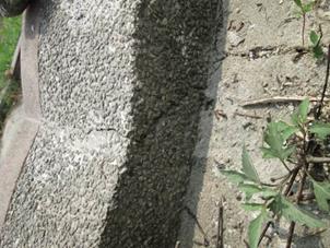
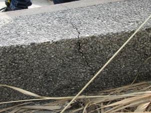
condition. However, a total of 10
cracks ranged from hairline to 2.8mm were identified in the cement rendering
and mortar of bricks of the grave. The
location of the cracks are shown in Figure
5.3. Detailed information
such as crack width and photographic record of the grave are summarized in Table
5.1.

Figure 5.3 Existing Cracks of the Grave G1
Table 5.1 Crack width and
Photographic record of the Grave G1
|
Crack No.
|
Crack Width
(mm)
|
Photographic
Record
|
|
1
|
Hairline
|
|
|
2
|
1.2
|
|
|
3
|
1.5
|
|
|
4
|
1.0
|
|
|
5
|
Hairline
|
|
|
6
|
1.0
|
|
|
7
|
1.6
|
|
|
8
|
1.3-4.0
|
|
|
9
|
2.5-2.8
|
|
|
10
|
0.8-2.1
|
|
5.5.1.1
All
measures undertaken by the Contractor during the construction phase in the vicinity
of the grave shall be audited by the Environmental Team (ET), on a regular
basis to ensure compliance with the intended aims of the recommended mitigation
measures. Site inspections should be undertaken at least once per week throughout
the construction period adjacent to these properties. The main aim of the
survey is prevention of any possible damage to the grave and to ensure that the
proposed mitigation measures are implemented. The broad scope of the audit will
involve supervision of the following:
Ÿ
non-contact
effects of the engineering works, such as vibration from pneumatic drills which
could cause damage, such as foundation or wall cracks and loosening of tiles or
fixtures; and
Ÿ
contact between the historic structures and equipment and materials associated
with the engineering works.
5.5.1.2
Specifically,
the monitoring programme will entail the following tasks:
Ÿ
the extent of the agreed works areas should
be regularly checked during the construction phase to ensure the buffer with a
minimum of 1.0m set back of the permanent structure and a minimum of 0.7m
clearance from the grave, can be maintained during construction, and
Ÿ
ensure no stockpiling or equipment storage is affecting the structures.
5.5.1.3
In
the event of non-compliance the responsibilities of the relevant parties is detailed
in the Event /Action plan provided on Table 5.2.
Table 5.2 Event
/ Action Plan for Cultural Heritage
|
Action Level
|
ET
|
IC (E)
|
ER
|
Contractor
|
|
Non-
conformity on one occasion
|
1. Identify Source
2. Inform the IEC and the ER
3. Discuss remedial actions with the IEC, the
ER and the Contractor
4. Monitor remedial actions until rectification
has been completed
|
1.
Check
report
2.
Check
the Contractor's working method
3.
Discuss
with the ET and the Contractor on possible remedial measures
4.
Advise
the ER on effectiveness of proposed remedial measures.
5.
Check
implementation of remedial measures.
|
1.
Notify
Contractor
2.
Ensure
remedial measures are properly implemented
|
1. Amend working methods
2. Rectify damage and undertake any necessary replacement
|
|
Repeated
Non- conformity
|
1. Identify Source
2. Inform the IC(E) and the ER
3. Increase monitoring frequency
4. Discuss remedial actions with the IC(E),
the ER and the Contractor
5. Monitor remedial actions until rectification
has been completed
6. If exceedance stops, cease additional monitoring
|
1.
Check
monitoring report
2.
Check
the Contractor's working method
3.
Discuss
with the ES and the Contractor on possible remedial measures
4.
Advise
the ER on effectiveness of proposed remedial measures
5.
Supervise
implementation of remedial measures.
|
1.
Notify
the Contractor
2.
Ensure
remedial measures are properly implemented
|
1. Amend working methods
2. Rectify damage and undertake any necessary replacement
|
Note:
ET �V Environmental Specialist, IEC �V
Independent Environmental Checker, ER �V Engineer��s Representative
6.1.1.1
The Baseline monitoring has been conducted
prior commencement of the construction works of the project in accordance with
the EM&A Manual of the TM-CLKL.
This Baseline Monitoring Report presents the baseline condition for air
quality, ecology, landscape and visual and cultural heritage.
6.1.1.2
Baseline air quality monitoring was conducted
by the ET of HyD Contract HY/2012/08 between 17 and
31 October 2013. The monitoring
results and established Action and Limit Level for 1-hour TSP and 24-hour TSP
would be adopted for this Contract.
6.1.1.3
Baseline survey for Pitcher Plant has been
conducted within the project area in September 2013 by a suitably qualified
ecologist. During the survey, a
total of 280 nos. of individual were identified in Zones 1 to 10 which were in
good condition. Moreover, an
initial survey for Pitcher Plant by the Contract HY/2013/12 was conducted in
mid-September 2014 to confirm the number of existing Pitcher Plant. A total of 280 nos. of individual
Pitcher Plant located at Zone 1 to 7 was identified. Since they are
occurring on the rocky slope habitat which will be impacted by the proposed
slope works (Zone 1 to 7), transplantation is required to minimize impacts to
the population.
6.1.1.4
Initial tree survey and photographic record
for existing Landscape was conducted on 22 September 2014 for TM-CLKL prior commencement of the
project.
6.1.1.5
Condition survey for the Grave G1 was
conducted on 23 September 2014. The
grave was generally in good condition.
However, a total of 10 cracks ranged from hairline to 2.8mm were
identified in the cement rendering and mortar of bricks of the grave.