CONTENTS
1.2 Purposes of Regular Marine Travel Routes (RMTR) Plan
1.3 Structure of Regular Marine Travel Routes Plan
2.0 DESIGN OF REGULAR MARINE TRAVEL ROUTES
2.2 Design Criteria of Regular Marine Travel Routes (RMTR)
2.3 Selected Regular Marine Travel Routes.
3.0 IMPLEMENTATION AND MONITORING
3.2 Method of Implementation and Monitoring
|
Appendix A |
- |
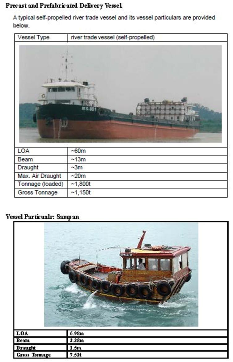
Working Fleets Particulars |
|
Appendix B Appendix C
|
- -
|
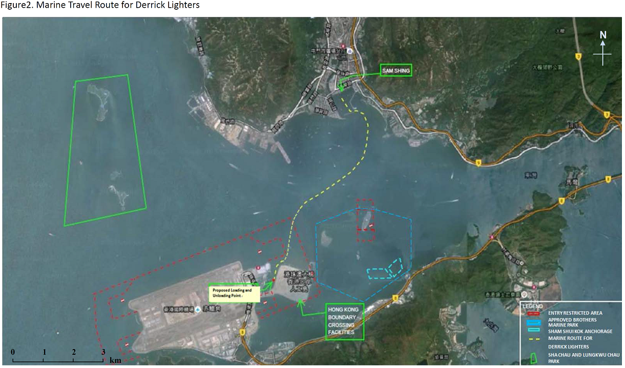
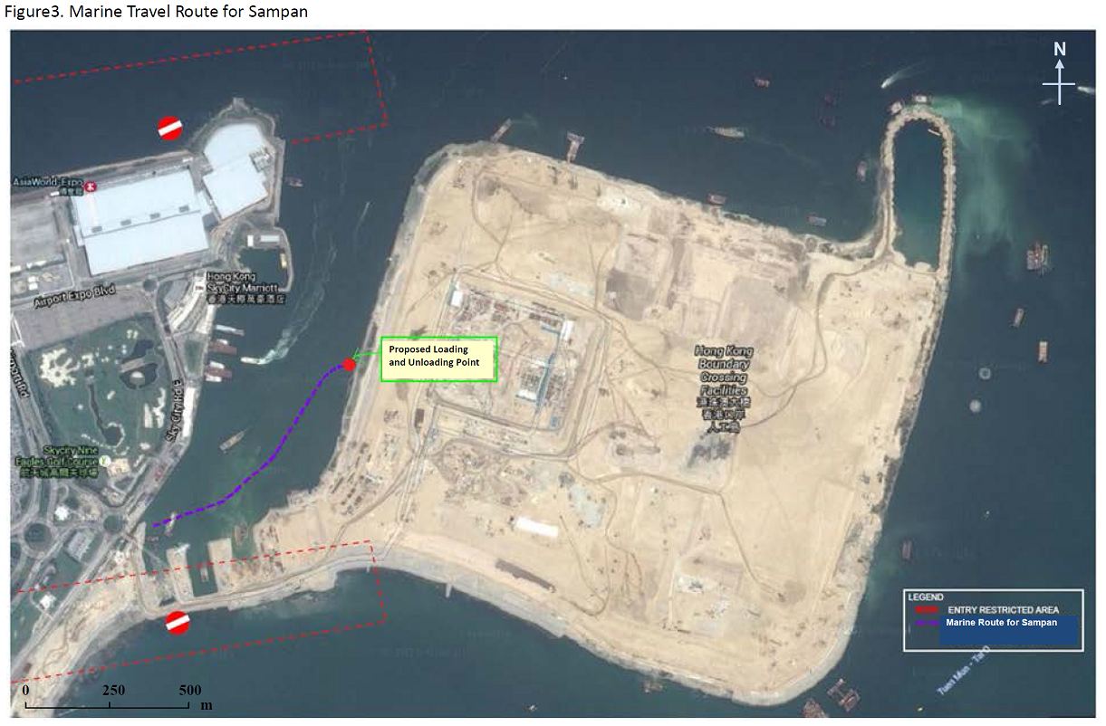
Dolphin Friendly – To Do and Not To Do Checklist Marine Travel Routes Figure 1. Marine Travel Routes for River Trade Vessels Figure 2. Marine Travel Route for Derrick Lighters Figure 3. Marine Travel Route for Sampan |
CHEC (China Harbour Engineering Company Limited, hereafter CHEC) are the Main Contractor to responsible for the execution of the construction works for the Hong Kong-Zhuhai-Macao Bridge (HKZMB) – Hong Kong Boundary Crossing Facilities (HKBCF) –Infrastructure Works Stage I (Western Portion) under Highways Department Contract number HY/2013/02. Due to change of construction method of viaduct from cast in-situ to segmental, marine delivery is required. The works to be executed under the Contract comprise the following major items of Works:-
· Construction of the viaducts and roads at the western portion of Hong Kong Boundary Crossing Facilities (HKBCF) mainly for connection with the Hong Kong – Zhuhai – Macao Bridge (HZMB), Hong Kong Link Road (HKLR), Hong Kong International Airport (HKIA) and the Tuen Mun-Chek Lap Kok Link (TM-CLKL);
· Construction of the road modification at the SkyCity Interchange at Airport Island;
· Construction of associated street lighting, street furniture, road marking, road signage, drainage, sewerage, fresh water and flushing water supply, irrigation, landscape, electrical and mechanical (E&M), utilities and services works;
· Provisioning of civil engineering works and power supply installation for the Traffic Control and Surveillance System (TCSS); and
· Other works in accordance with the Contracts.
The purpose of this Regular Marine Travel Routes Plan is to present the design principal, implementation and monitoring method for RMTR in order to minimize the chance of vessel collision and the disturbance to the Chinese White Dolphins (CWD). This RMTR plan is taken by CHEC and its subcontractors and suppliers during the construction activities that involve using the marine travel routes within Hong Kong for this contract.
The preparation and implementation of this Regular Marine Travel Routes Plan is a mandatory requirement under section 2.8 of the Environmental Permit no. EP-353/2009/K.
Following this introductory sections, the remainder of the report is presented as follows:
· Section 2 presents the Design Criteria of Regular Marine Travel Routes Plan;
· Section 3 presents the Implementation and Monitoring of Regular Marine Travel Routes Plan; and
· Section 4 is the Summary and Conclusion
2.0 DESIGN OF REGULAR MARINE TRAVEL ROUTES
The following paragraphs presents the introduction of construction activities and particular of working vessels that will be allocated in this Project in order to identify the potential risks / impacts and mitigation measures to minimize impacts to CWD during the construction stage.
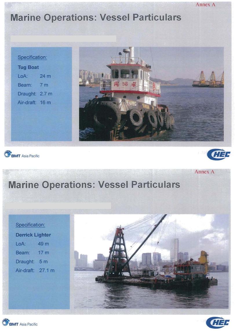
The ship particulars of derrick lighter deployed for the construction of temporary loading and unloading point, river trade vessel for the delivery of precast and prefabricated unit and sampan for passenger transportation are attached in the Appendix B. Considering potential impact to CWD, these working fleets can be divided into three categories:
a) Non-self-propelled Working Fleets in the vicinity of temporary loading and unloading point
The working fleeting classed in this category includes derrick lighter. Tug boats will be used to tow and to assist the positioning and anchoring. As these working fleets will mainly station in the vicinity of temporary loading and unloading point and the maneuvering or positioning will be carried out in slow speed, the potential impact to CWD will be low.
b) Self-propelled Working Fleets in the vicinity of temporary loading and unloading point
The working fleeting classed in this category includes tug boats and sampan for general usage and passenger. As the construction activities are mainly carried out in the vicinity of temporary loading and unloading point, and since most of working fleets will be slow-moving (around 5 knots up to maximum 10 knots), therefore traffic disturbance or collision risk will be low in this cases.
c) Delivery material to the vicinity of temporary loading and unloading point
The working fleeting classed in this category includes precast and prefabricated delivery barges. The potential of a cumulative marine traffic disturbance or collision risk due to the large-sized and fast-moving (>10 knots) working fleets traffic flow during construction stage will affect the CWD. Therefore, controlling of marine traffic disturbance on CWD such as speed limits and regular routes will be implemented.
The design criteria of RMTR are summarized as follows:
a) Hotspots of Chinese White Dolphin in Brothers Island
Latest available data of monitoring of marine mammals in Hong Kong Waters collected under the Project and issued by Agriculture, Fisheries and Conservation Department (AFCD) ( http://www.afcd.gov.hk/english/conservation/con_mar/con_mar_chi/con_mar_chi_chi/con_mar_chi_chi.html ) and the EM&A report of HZMB projects will be used as reference information to align the marine travel routes of project related work fleets (.The fundamental principle is that the routes will not go through the dolphin hotspots in Brothers Island.
b) Existing Navigation Channel and Marine Traffic
Further to the safe navigation requirement in-law and Existing Fairway Plan, the design of marine travel routes will be followed. Existing fairways such as Hung Hom Fairway, Central Fairway, Northern Fairway and Ma Wan Fairway as well as Urmston Road Channel will be selected as the main travel routes for delivery of material to temporary loading and unloading point.
Due to such large volume of marine traffic in Urmston Road Channel, the project related working fleets are required to draw extra attention and safety awareness while passing through this region. The marine travel routes will be locally adjusted so as to minimize the potential risks of marine traffic incident.
c) Practice of Navigation Safe
The licensed captain is the authorized person to control the working fleeting under safe marine operation. He will follow all safe navigation requirement and international practice with assistance from navigation aids as well as support from marine traffic control team of Marine Department.
The marine travel route will be adjusted locally to cater for any incident so as to ensure safe navigation. For example, while ocean liner are using Ma Wan Channel and Urmston Road Channel, small project related working fleets needs to “give way” to such large-sized oceangoing vessels when the travel routes are overlapped. Other marine operators such as speed boats, turbo jets, container vessels, river trade vessels and the like may also affect the marine travel routes of project related working fleets.
Marker buoys and navigation buoys are the best marine based indicators to demarcate the proper navigation channel and are very useful tool to assist captain to determine the proper travel routes under real situation and any unexpected incidents.
Moreover, the navigation will also be affected by natural constraints such as wind, current, wave, etc. which may also affect the marine travel routes locally.
d) Restricted Areas and Height Restriction of Hong Kong International Airport
Regarding Airport Height Restriction and Airport Restricted Area, there are seven prohibited and restricted areas in the vicinity of Hong Kong International Airport where working fleets are not allowed to pass through unless authorization is granted#1
#1 Area No.1-4: No vessel shall enter or pass through;
Area No.5–6: No vessel which has a height exceeding 15m above sea level shall enter or pass through;
Area No. 7: No vessel which has a height exceeding 30m above sea level shall enter or pass through.
e) Other Site Constraints
Existing marine parks, anchorage areas in Sham Shui Kok and Tuen Mun and the like are also considered during designing the proper marine routes for this Project.
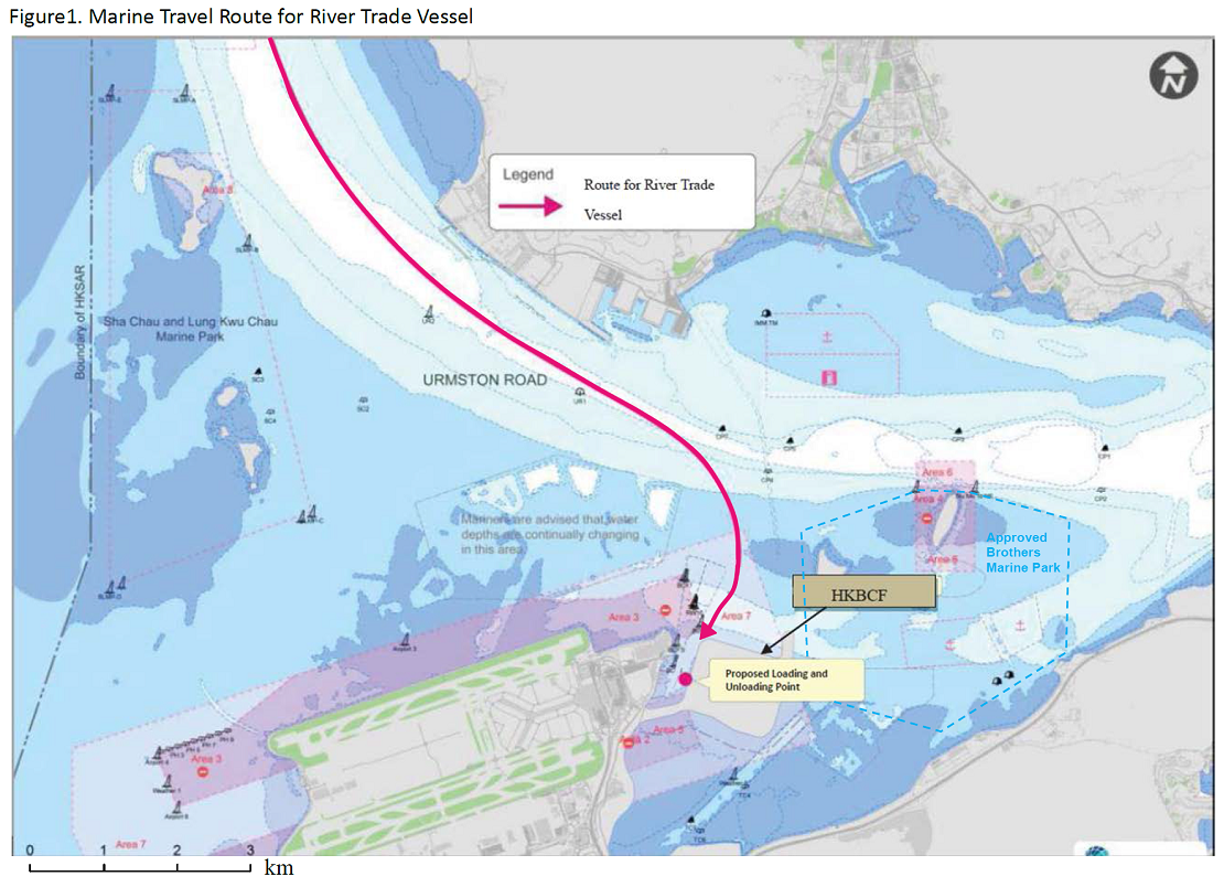
Based on the abovementioned designed criteria, the marine travel routes of Delivery of Precast and Prefabricated Units are designed and presented in Appendix C.
However, these marine travel routes will be locally modified for the purpose of catering for the sighting of CWD and safe marine operation under real marine traffic conditions, weather conditions and any unexpected incident.
The precast and prefabricated unit delivery will be carried by self-propelled river trade barge enters Western Waters of Hong Kong and towards the Airport via Urmston Road. The transit will maintain at the North of Urmston Road (in-shore traffic zone). The transit will then cross Urmston Road at the shortest path to arrive at Sky Pier Basin. As to further minimize the potential impact to CWD within Brothers Island Water, speed of the delivery barge will be controlled below 5 knots.
3.0 IMPLEMENTATION AND MONITORING
The Project Director is the ultimate person for minimizing any ecological impacts including dolphin monitoring and marine traffic control. The supervising staff including Project Manager, Construction Manager, Superintendent, Site Foreman and the representative of subcontracts and specialist will assist the Project Director onsite to implement all precautionary and mitigation measures approved by the Statutory Authority and the Engineer.
The construction works are divided into onsite and offsite works. Onsite works include all construction activities of temporary loading and unloading point. As the working fleets are mainly stationed within the works boundary and occasionally will be relocated to suit the working progress, the potential impacts to CWD will be low.
Offsite works are mainly the delivery of precast or prefabricated unit.
This working fleet will pass through Urmston Road Channel and marine travel routes control will be implemented.
i) Precast and prefabricated unit from Pearl River Estuary
GPS system or course recorder system will be installed for the purposes of recording the marine travel route.
ii) Other project related working fleets
Tug boats will install GPS system or course recorder system for recording marine travel route during tow operation.
The marine travel records and graphical plots of all the vessel tracks overlaid on HK base map will be provided at monthly interval to ER, ETL, IEC/ENPO to demonstrate the conformance of the vessel to the proposed route. Warning will be noticed to the captain and his shipping company or material supplier if vessel track log showed the approved marine travel route is not followed.
a) Considerations of Operation Procedure
The main issue with the Chinese White Dolphin (Sousa chinensis) is a moving vessel striking and injuring an animal during the period of travel. Information regarding the locations of frequent sighting near the proposed vessel routes indicated that the following would also be needed to minimize the chance of a vessel striking a dolphin.
i) On leaving the entrance in the silt curtain, all vessels will travel at a speed not greater than 5 knots for a distance of 250m then at a speed no greater than 10 knots for a distance of at least 1.5km away. Vessels can then increase speed after that distance unless other restrictions apply.
ii) If any dolphins are sighted within 250m of a vessel then the vessel will slow to a speed no greater than 5 knots for at least 12 minutes after the last sighting.
b) Skipper Training
All captains of project related working fleets and the supervising staff should undergo training to learn about local dolphins and porpoises. They should be trained to be aware of the protocol for “dolphin friendly” vessel operation (refer to the Code of Conduct for Dolphin Watching Activities from AFCD). The “To DO and Not to Do Checklist” is attached in Appendix B for more details.
The training will be conducted by Environmental Officer/Environmental Supervisor of the Project. This training course has been well developed by Contract No. HY/2010/02, Contract No. HY/2013/02 will follow and provide the same training course (Including the considerations of operation procedure mentioned in Section 3.3a) to captains within three working days after start working onsite and refreshment course will be provided in every quarter.
This RMTR Plan presents a review of major construction works, working fleets particulars and design criteria of marine travel routes. Based on this review, preferred marine travel routes for different construction works are recommended. Method of implementation and monitoring as well as precautionary measures are proposed to minimize any potential impacts to Chinese White Dolphin during the course of delivery work.
Appendix A
Working Fleets Particulars
Appendix B
Dolphin Friendly – To Do and Not To Do Checklist
Dolphin Friendly – TO DO and NOT TO DO CHECKLIST
TO DO
1) Always slow down to no-wake speed, and stop if dolphins appear directly ahead within 100m.
2) Keep vessel at a slow, steady speed without sudden course changes. Boat speed should not exceed 10 knots.
3) Never conduct reverse throttling when dolphins are nearby.
NOT TO DO
1) Do not litter or discharge any pollutants into the sea
2) Never touch, swim with, or feed dolphins
3) Never chase or intercept the course of dolphins, separate mothers and calves or ‘corner’ dolphins
4) Never approach dolphins head on
Appendix C
Marine Travel Routes